ESSEXVALE (new Zimbabwe name - Esigodini)
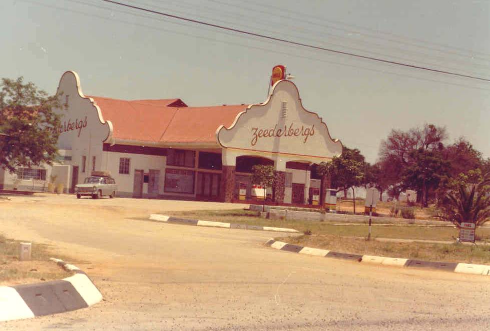
Zeederbergs filling station - an Essexvale landmark on the main road from Bulawayo to Beit Bridge
Rhodesian Place Names
ESSEXVALE (new Zimbabwe name - Esigodini)
Zeederbergs filling station - an Essexvale landmark on the main
road from Bulawayo to Beit Bridge
Latitude 20º 20 S,
Longitude 28º 57 E, Altitude 3,828 m (1,160
feet), Rainfall 760 mm (30 inches)
The region around Essexvale was, prior to the Matabele occupation, inhabited by
the Rozi Moyo people, who had migrated from the territory around Gwanda and
Belingwe.
The township was founded in 1894 and originally consisted of an estate of nearly
200,000 acres. Frederic C. Selous, who contracted to guide the pioneer column to
Mashonaland had an interest in the Company owning the estate, but left the
country after fulfilling his contract. He returned in 1895, and took up
residence on the estate.
He erected a wire-wove house which he ordered from the United Kingdom, on top of
a cliff 25 metres above the Ingnaima River. Selous was assisted by a young
German, Herr Blocker, who was the forest officer on the estate. It was the
Company's intention to plant large quantities of gum trees.
During the Matabeleland Rebellion of 1896, Selous left the estate and assisted
in quashing the rising, but during his absence the house was burnt down by
Inxnogan, of the rebellious Matabele indunas. When the Rebellion was over, he
wrote a book of his experiences, entitled Sunshine and Storm in Rhodesia, and
retired to England.
The village is situated 37 km from Bulawayo by road and 47 km by rail on the
Bulawayo-West Nicholson line. The area contains two gold belts on which there
were several mines, the largest of which was the Bushtick. The main gold belt
originates in the Filabusi district and runs through the estate in a northerly
direction. The other, branches off near Balla Balla peak and runs west,
terminating in the granites of the Bulalima district. Tungsten is also found in
the area.
The grass of the district, which was known as Godhlwayo is of an excellent
quality, and the area supported large herds of Lobengula's cattle, who once said
that the cattle of Godhlwayo were as many as locusts.
Bulawayo receives its water supply from the Ncema dam which is situated on the
estate. Before the establishment of Essexvale as a township, the Administrative
centre was at Makukupen, which was opened as a police post in 1896. H. M.
Jackson, who later became a Chief Native Commissioner was in charge. There was
also a store which ran a postal agency and served the gold mine, which lay about
a kilometre to the south east. Makukupen (meaning chicken) was the name of a
headman who had his village at the foot of the Scoveni Hills, 7 km south-west of
Essexvale. The Post Office was subsequently transferred to the farm, Widgeon,
which was owned by Russell Brown. After his death, the agency was carried on by
his wife for many years and when it was finally closed in 1965, it had been
operated by the Brown's for a period of 37 years.
The area consists of farms and ranches, and the countryside has very little
natural timber. The area is well watered - nearly every farm having a perennial
stream. The farms of the district are situated on a high plateau south of the
Shashi River. Other rivers rising in the vicinity are the Devuli, Popotekwe,
Mtelekwe and Umshagashi.
The locality is on a gold belt and many small gold deposits have been
discovered. South of the gold belt is situated a well known hill, called Zomo,
which is fairly high and can be seen from afar. Like many other such hills in
the country, it contains a number of ancient workings. The Welcome and Ilanga
mines, situated 150 metres apart, were re-opened in 1960.
Return to Rhodesian Place Names
Most of the information on this page is
extracted from the books :
"Avondale to Zimbabwe" written and published by R.
Cherer Smith ISBN 0-7974-0313-2 and
"Tabex Encyclopedia Zimbabwe" © Quest Publishing
ISBN 0-908306-04-0
with additional notes and photographs by the webmaster and other
contributors as acknowledged.